Oskari architecture
The big picture
Oskari helps businesses and municipalities offer better online and mobile map services to their citizens and consumers.
It is not a turnkey solution, but instead provides software components used in online service creation, leveraging geospatial data from standardised APIs.
The Platform integrates off-the-shelf Open Source geographical software products with off-the-shelf Open Source software libraries and custom Oskari software components to allow the interleaving and integration of many different sources of geographical and statistical data into online map visualizations that help power e-government services and decisionmaking processes.
The component architecture
Oskari includes a frontend, a backend and in the future also a service bus.
The user interface is implemented in JavaScript and the server functionality in Java.
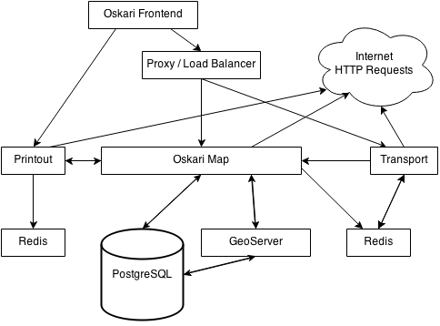
The picture below shows the components of Oskari.
For a more detailed view of the architecture, see the frontend architecture and the backend architecture documents.

Browser - Oskari frontend
- Firefox
- Chrome
- Internet Explorer
- Safari
Proxy/Load balancer
- HAProxy
- Apache
- Nginx
- F5 load balancer
Oskari-map
- Jetty
- Tomcat
Transport/Redis
- Jetty
Database
- PostgreSQL
Last modified: Mon Jun 24 2024 15:11:03 GMT+0300 (Eastern European Summer Time)
