coordinatetool
Description
This bundle provides a plugin (Oskari.mapframework.bundle.coordinatetool.plugin.CoordinateToolPlugin) for mapmodule that can:
- shows coordinates on mouse location
- shows coordinates on mouse map click
- center map to given coordinates
- add marker with given coordinates
- as optional functionality coordinate transformation form one coordinate system to another can be added to the coordinatetool (configuration is needed)
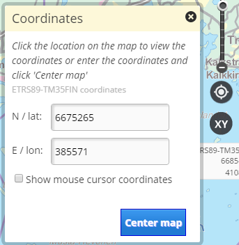
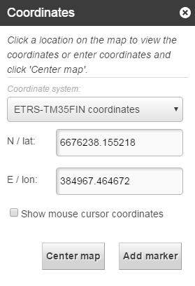
Screenshot
Bundle configuration
No configuration is required, but there is few possible configurations:
- Setting
projectionShowFormatto configure how different projections are showed in textfields. This setting supports all projections or projection specific configuration. In both of thesemetricproperty define decimal plates (if format isdegreesthen this seconds is rounded to wanted decimals),formatproperty define showed format (degreesormetric). If not setted then metric format and 0 decimals are default. if projectionShowFormat not defined then using map units and this decimals.- Option to change all projections formats
{
        "format": "degrees",
        "decimals": 4
}- Option to different projections
{
        "EPSG:4258": {
            "format": "degrees",
            "decimals": 4
          },
        "EPSG:3067": {
            "format": "metric",
            "decimals": 0
        }
}- Or you can also define defaults and override some projections. Projection defination overrides defaults.
{
        "format": "degrees",
        "decimals": 4,
        "EPSG:3067": {
            "format": "metric",
            "decimals": 0
        }
}- Option to configure coordinatetool to show reverse geocode for the current position ( bundle config in the view in portti_view_bundle_seq table)
{
      "isReverseGeocode": true,
      "reverseGeocodingIds": "WHAT3WORDS_CHANNEL"
}- Option to configure XY reference system changing functions (CRS code and view uuid,..)
{
      "supportedProjections": {
          "EPSG:3035": "482333d1-f0d0-4410-aa65-60db4e45b853",
          "EPSG:3857": "1d65e6cc-4ac7-4dab-8a94-76b3dd632307"
      }
}- Option to configure coordinate transformation tool:
{
      "supportedProjections": [
        "EPSG:3067", "NLSFI:etrs_gk", "NLSFI:ykj",
        "EPSG:4258", "LATLON:kkj", "EPSG:3046",
        "EPSG:3048", "EPSG:3873", "EPSG:3874",
        "EPSG:3875", "EPSG:3876", "EPSG:3877",
        "EPSG:3878", "EPSG:3879", "EPSG:3880",
        "EPSG:3881", "EPSG:3882", "EPSG:3883",
        "EPSG:3884", "EPSG:3885"
      ]
}- Option to configure XY-icon not visible (for example coordinatetools is used in published map and it's opened/closed by RPC request):
{
    "noUI": true
}- Option to configure to show emergency call message:
{
    "showEmergencyCallMessage" : true
}
Requests the bundle sends out
| Request | Where/why it's used |
|---|---|
| `MapMoveRequest` | Move map to selected coordinates. |
Events the bundle listens to
| Event | How does the bundle react |
|---|---|
| `MouseHoverEvent` | Updates the coordinates gotten from event to the UI. |
| `AfterMapMoveEvent` | Updates the updated coordinates for map center. |
| `MapClickedEvent` | Updates the coordinates gotten from event to the UI. |
| `Publisher.ColourSchemeChangedEvent` | Updates the UI colour schema from event. |
| `Publisher2.ColourSchemeChangedEvent` | Updates the UI colour schema from event. |
Dependencies
| Dependency | Linked from | Purpose |
|---|---|---|
| jQuery | Assumes to be linked in the page | Used to create the component UI from begin to end |